Building Information Modelling (BIM) Surveys
SOCOTEC, formally Aspect Land & Hydrographics Ltd. provide BIM surveys and measured building surveys that capture, process and deliver accurate spatial data for digital modelling and project workflows.
Our modelling practices align with BS EN 19650, enabling seamless integration into wider BIM environments.
What is BIM Surveying?
BIM surveys combine accurate site data capture with digital modelling to produce structured 3D models and survey outputs suitable for Building Information Modelling workflows.
SOCOTEC capture survey data through multiple methodologies including:
Topographic surveys
Measured building surveys
GPR / utility mapping
Terrestrial laser scanning
Bathymetric surveys
This information is processed to generate BIM-ready models that can integrate into wider project environments and digital workflows.
Our modelling practices align with BS EN 19650, allowing models to be easily incorporated into collaborative BIM environments following project handover.
To date, SOCOTEC has completed numerous 3D models, primarily developed in Revit, across a range of sectors including:
Architectural refurbishment projects
Marine infrastructure
Transport infrastructure
These models provide a digital representation of existing assets that can be used for design development, planning, and asset management.

How BIM works

Discovery
Project requirements are reviewed to determine the appropriate survey techniques and modelling scope required for the BIM deliverables.

Execution
Survey data is captured on site using specialist equipment to gather accurate spatial information across buildings, infrastructure and surrounding environments.

Validation
Collected datasets are processed and verified before being converted into structured 3D models or survey drawings suitable for BIM environments.
Model Delivery
The final BIM models and associated survey data are delivered in formats suitable for integration into client workflows and BIM systems.
Our Building Information Modelling in Action
Aspect has delivered BIM models across a range of sectors and project environments.
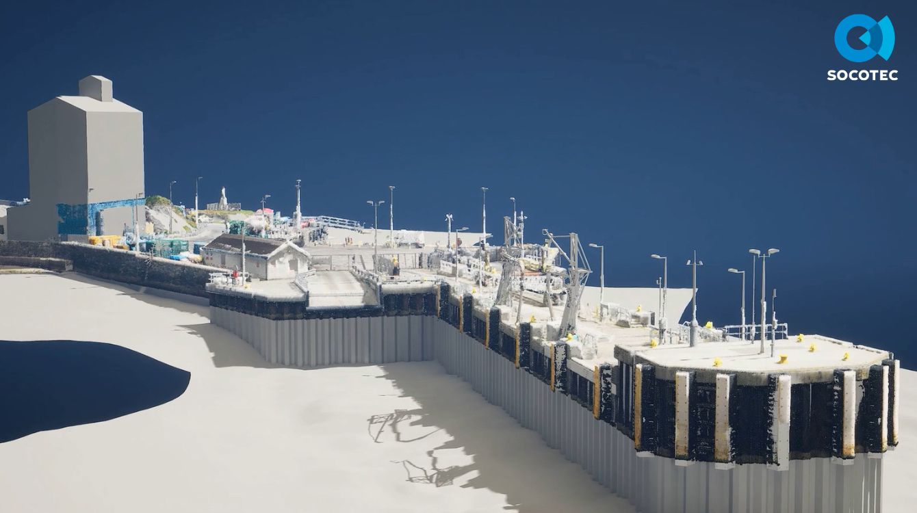
Examples include marine infrastructure modelling, where above-water survey data is combined with land survey data to create continuous digital models. These can include features such as:
Dock walls
Sheet piling
Seabed modelling derived from side-scan sonar or multibeam bathymetric data
Sub-strata layers of the seabed can also be incorporated to provide a centralised, holistic view of the full site environment.
BIM Surveys
Why Choose SOCOTEC
Integrated Survey Capabilities
Aspect combines multiple survey disciplines including land, hydrographic and geophysical surveys to produce complete BIM-ready datasets.
BS EN 19650 Alignment
Modelling practices align with the BS EN 19650 BIM standard, supporting integration into collaborative project environments.
Flexible Levels of Detail
Models can be developed with different levels of detail depending on project requirements and intended future use.
Specialist Modelling Expertise
In-house technicians create BIM models tailored to each client’s needs and ensure that appropriate modelling standards are applied.
Cross-Environment Modelling
Survey data can integrate land and marine datasets into a single coordinated BIM model where required.
Learn More about BIM Surveys
What level of detail can a BIM survey include?
Survey detail can be tailored to suit client requirements and budgets, from basic layouts showing wall positions, ceiling heights and openings, to highly detailed models including services, lighting, fixtures and furniture.
Can BIM models be generated from measured building surveys?
Yes. Survey data can be converted into 3D models that provide a real-world visualisation and can be imported into BIM systems.
Which software formats can BIM models be delivered in?
Aspect primarily develops models in Revit, but datasets can be delivered in formats suitable for integration into BIM workflows.
Let's Talk
We can can deliver accurate spatial data and BIM-ready models tailored to your project requirements.

Discover our latest News & Media

Fire Resistance: Everything you wanted to know but were afraid to ask

Nature Positive Real Estate: Creating Value through Biodiversity
UKTC opens multi-million-pound state-of-the-art second firehall

Infinito Delicias. Building low-carbon spaces for communities to thrive

Mass Data Capture in Modern Surveying