Underwater Imagery Surveys
High-resolution stills and video support inspection and reporting, with survey activity guided live by experienced marine surveyors as a practical, cost-effective alternative to diver-led operations where appropriate.
Underwater imagery surveys deliver clear, reliable visual insight into seabed conditions, underwater assets and sensitive marine environments. Using cameras and sonar deployed from Remotely Operated Vehicles (ROVs) or fixed systems, imagery is collected to identify debris, assess seabed features and review the condition of underwater infrastructure.
All data is viewed topside in real time, allowing survey activity to be directed immediately towards areas of interest. This ensures survey effort remains focused, efficient and proportionate to each project’s objectives.

Underwater Imagery Surveys
Clear insight where access and visibility are limited

Gaining a clear understanding of seabed conditions or underwater assets is often constrained by limited visibility, access and safety considerations. Traditional diver-led inspections can also be restricted by depth, range and environmental conditions.
SOCOTEC, formerly Aspect Hydrographic Surveys Ltd, delivers underwater imagery surveys as a dependable alternative, providing consistent and repeatable visual records without unnecessary intervention. This supports confident decision-making for asset owners, regulators and project teams working in offshore and nearshore environments.
A proportionate, experience-led approach
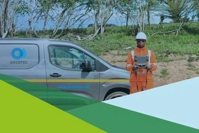
We deliver underwater imagery surveys through experienced marine surveyors with direct offshore and nearshore project experience. Survey methods are selected based on site conditions and survey objectives, using the most appropriate combination of cameras, ROVs and sonar systems.
By combining proven imagery methodologies with our wider environmental and asset expertise, we ensure survey outputs are not only clear, but meaningful, proportionate and ready to use.
Gaining a clear understanding of seabed conditions or underwater assets is often constrained by limited visibility, access and safety considerations. Traditional diver-led inspections can also be restricted by depth, range and environmental conditions.
SOCOTEC, formerly Aspect Hydrographic Surveys Ltd, delivers underwater imagery surveys as a dependable alternative, providing consistent and repeatable visual records without unnecessary intervention. This supports confident decision-making for asset owners, regulators and project teams working in offshore and nearshore environments.
A proportionate, experience-led approach
We deliver underwater imagery surveys through experienced marine surveyors with direct offshore and nearshore project experience. Survey methods are selected based on site conditions and survey objectives, using the most appropriate combination of cameras, ROVs and sonar systems.
By combining proven imagery methodologies with our wider environmental and asset expertise, we ensure survey outputs are not only clear, but meaningful, proportionate and ready to use.
Better understanding of assets and seabed conditions
Underwater imagery surveys help you to:
- Assess asset condition without routine diver entry where feasible
- Identify seabed features, debris and anomalies with confidence
- Support environmental assessments through visual ground-truthing
- Build reliable historical records of seabed and asset condition
- Target further survey or inspection works accurately
- 3D Visualisation
- 3D Digital Twins
- Hi-resolution georeferenced mosaic Images
Underwater imagery surveys provide high-resolution still imagery, video and georeferenced seabed mosaics to support inspection, environmental assessment and subsea asset management. Using ROV-mounted cameras, sonar systems and real-time topside monitoring, our marine surveyors capture clear visual records of seabed features, infrastructure condition and anomalies, enabling informed decision-making without routine diver intervention.
Underwater Imagery Surveys
Why choose SOCOTEC
Experienced Marine Survey Teams
Our underwater imagery surveys are delivered by experienced marine surveyors with direct offshore and nearshore project experience. This operational understanding ensures imagery collection is guided effectively during live surveys and focused on areas that matter most to the project.
ROV and Remote Inspection Capability
Using ROV-mounted cameras, sonar systems and fixed imaging platforms, we provide reliable subsea inspection without routine diver intervention where appropriate. This approach improves safety, increases operational flexibility and enables surveys in environments where diver access may be limited.
Real-Time Survey Control
All imagery is viewed topside in real time, allowing surveyors to direct ROVs and camera systems immediately towards areas of interest. This ensures survey effort remains efficient while providing clear visual evidence of seabed conditions, infrastructure and anomalies.
High-Resolution Visual Data and Deliverables
Our surveys produce high-resolution still images, video footage, georeferenced mosaic imagery and photogrammetry outputs. These deliverables provide clear visual records suitable for technical inspection, environmental review and asset condition reporting.
Integrated Marine Survey Expertise
Drawing on our heritage in hydrographic, geophysical and environmental surveys, underwater imagery surveys can be integrated with wider marine survey programmes to provide a more complete understanding of subsea conditions and assets.
Beach Erosion Surveys: Methods, Measurement and Outputs
What is an underwater survey?
An underwater survey involves collecting data beneath the water’s surface to understand seabed conditions, underwater assets or the surrounding marine environment. Depending on the objective, surveys may use visual imagery, sonar or other remote sensing techniques.
Underwater imagery surveys focus specifically on capturing high-quality images and video, providing clear visual evidence to support inspection, assessment and environmental understanding.
What is a subsea survey?
A subsea survey is a type of underwater survey that concentrates on features located on or just above the seabed. This typically includes pipelines, cables, outfalls, foundations and other subsea infrastructure.
Underwater imagery plays a key role in subsea surveys by providing close-range visual confirmation of asset condition and identifying scouring, damage or debris that may not be fully apparent in acoustic data alone.
What are the methods of surveying underwater features?
Underwater features can be surveyed using a range of methods, selected according to water depth, visibility, access and survey objectives. Within underwater imagery surveys, common methods include:
- ROV-mounted cameras for flexible, close-range inspection
- Tripod-mounted or fixed camera systems for repeat or longer-term monitoring
- Side-scan sonar to produce mosaic images highlighting seabed features and objects
These approaches allow imagery to be reviewed in real time, enabling survey teams to adapt works efficiently and focus on areas of interest.
What is an IWS survey?
IWS refers to Imagery and Visual Surveys, describing underwater surveys that rely on video and still imagery rather than intrusive inspection methods.
Underwater imagery surveys form a core part of this approach, providing reliable visual records of seabed conditions, underwater assets and environmental features without the need for routine diver entry.
What is an underwater photogrammetry survey?
Underwater photogrammetry creates precise, measurable 3D models and digital replicas of submerged objects or terrain by processing multiple, overlapping 2D images captured by ROVs. This non-invasive technique is used for high-accuracy inspections of underwater structures, archaeological surveys of shipwrecks, marine habitat monitoring and object identification. Photos (often with 60%+ overlap) are taken of a target and processed in specialised software (Agisoft Metashape), where images are aligned along with camera positions to generate dense and textured 3D point clouds.
Underwater Imagery Survey Methods
ROV-mounted video and still imagery
ROV-mounted systems provide flexible, close-range visual inspection of the seabed and underwater assets. Video footage is typically supplied with professional narration describing seabed composition, pipeline routes, outfall locations and any significant findings such as scouring or damage. Accurate Positioning of the ROV is achieved by combining surface GNSS/GPS with subsea acoustic, inertial, and velocity sensors.
Tripod-mounted and fixed camera systems
Tripod-mounted cameras are well suited to longer-duration monitoring or repeat surveys in defined locations. These systems allow consistent positioning, supporting direct comparison of seabed conditions over time.
Side-scan sonar imagery
Side-scan sonar data can be supplied as mosaic images to highlight seabed features, objects and anomalies. This approach is particularly effective for wider-area seabed assessment and object detection.
Environmental and seabed characterisation
From an environmental perspective, underwater imagery is used to ground-truth multibeam backscatter data and support seabed characterisation. Imagery also contributes to habitat identification and environmental baseline studies.
Typical Outputs and Deliverables
Survey deliverables are tailored to project requirements and may include:
- High-resolution underwater digital stills
- Photogrammetry
- Georeferenced mosaic images
- ROV or fixed-camera video footage
- Side-scan sonar mosaic images
- Clear reporting suitable for technical and environmental review
Typical Applications
Underwater imagery surveys are commonly used for:
- Pipeline and underwater cable inspections
- Bridge pier, pontoon and dock wall condition assessments
- Water, sewer and outfall inspections
- Seabed habitat monitoring and assessment
- Debris, wreck, pUXO and object detection
- Search and recovery of missing assets
Discover latest News & Media

Fire Resistance: Everything you wanted to know but were afraid to ask

Nature Positive Real Estate: Creating Value through Biodiversity
UKTC opens multi-million-pound state-of-the-art second firehall

Infinito Delicias. Building low-carbon spaces for communities to thrive
Mass Data Capture in Modern Surveying