Bathymetry Surveying
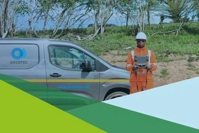
SOCOTEC, formally known as Aspect Land & Hydrographic Surveys Ltd provides comprehensive Bathymetric survey solutions using both Singlebeam and Multibeam technologies.
Organisations working in coastal engineering, marine construction, ports, waterways, energy and environmental management rely on dependable underwater data to reduce risk and improve decision‑making. Bathymetry helps overcome challenges such as unknown seabed conditions, sedimentation changes, navigational hazards, dredging inaccuracies, compliance requirements and long‑term asset monitoring.

Bathymetry Surveying
What Is Bathymetry?
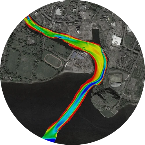
Bathymetry is the measurement and mapping of underwater topography - essentially the underwater equivalent of land surveying. Using sonar technology, we collect water depth data to produce charts, profiles, and 3D models of the seabed, riverbed, lakes, reservoirs, and other water bodies.
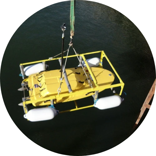
We deploy both Singlebeam and Multibeam echosounders, allowing us to tailor the survey method to the project area, resolution requirements, and environmental conditions.
At SOCOTEC, our network of hydrographic experts deploy modern survey vessels, precise GNSS positioning and industry‑approved sonar technology to collect reliable underwater data. Whether delivering assessments or detailed 3D seabed models, we work collaboratively with clients to deliver accurate insights that support safer and more efficient project delivery.
Bathymetry is the measurement and mapping of underwater topography - essentially the underwater equivalent of land surveying. Using sonar technology, we collect water depth data to produce charts, profiles, and 3D models of the seabed, riverbed, lakes, reservoirs, and other water bodies.
We deploy both Singlebeam and Multibeam echosounders, allowing us to tailor the survey method to the project area, resolution requirements, and environmental conditions.
At SOCOTEC, our network of hydrographic experts deploy modern survey vessels, precise GNSS positioning and industry‑approved sonar technology to collect reliable underwater data. Whether delivering assessments or detailed 3D seabed models, we work collaboratively with clients to deliver accurate insights that support safer and more efficient project delivery.
Bathymetry Surveying
What Bathymetry do I need?
Choosing the right Bathymetry method depends on the coverage and detail you need: Multibeam Bathymetry is the best option when you require full‑coverage mapping, high‑resolution 3D seabed models, backscatter imagery or detailed hazard detection, as its integrated GNSS/INS systems routinely achieve high‑order hydrographic standards and minimise tide‑related error.
In contrast, Single Beam Bathymetry is ideal for cost‑effective depth profiles in rivers, channels and shallow or constrained areas where achieving complete seabed ensonification with Multibeam would be too time‑consuming or outside budget; dual‑frequency echosounders also allow penetration through soft silt to the harder seabed below, which is particularly useful for dredging, construction and environmental sediment mapping projects.
Our network of hydrographic experts deploy modern survey vessels, precise GNSS positioning and industry‑approved sonar technology to collect reliable underwater data. Whether delivering assessments or detailed 3D seabed models, we work collaboratively with clients to deliver accurate insights that support safer and more efficient project delivery.
Singlebeam Bathymetry
What does Single beam Bathymetry entail
Singlebeam bathymetry collects water depth directly beneath the survey vessel along defined profiles. It is a cost‑effective and reliable method, ideal for linear or long‑section surveys where full seabed coverage is not required.
Singlebeam Batheymetry Applications
- River and channel cross‑sections
- Small inland water bodies such as lakes, reservoirs and ponds
- Dredge monitoring
- Environmental and sedimentation studies
- Pre‑ and post‑construction coastal inspections
Key Advantages of Singlebeam Bathymetry
- Efficient for linear survey paths
- Suitable for shallow or constricted waterways
- Lower mobilisation and processing costs
- Effective for long‑term monitoring programmes
Typical Singlebeam Bathymetry Deliverables
- Depth profiles along survey lines
- Cross‑sections
- Contour plans
- XYZ datasets for modelling
- Sediment profiles
Multibeam Bathymetry
What does Multibeam Bathymetry entail
Multibeam Bathymetry produces full‑coverage seabed mapping using a swath of acoustic beams, capturing high‑density 3D data across the entire underwater surface.
Multibeam Batheymetry Applications
- Marine construction planning
- Offshore infrastructure inspections
- Dredging design and QA/QC
- Seabed classification and habitat mapping
- Wreck and hazard detection
- Coastal erosion and morphology studies
Key Advantages of Multibeam Bathymetry
- Complete seabed coverage
- High‑resolution 3D modelling
- Excellent for complex topography
- Suitable for engineering‑grade datasets
Typical Multibeam Bathymetry Deliverables
- High‑density point clouds
- Digital Terrain Models (DTMs)
- Shaded relief maps
- 3D visualisations
- Backscatter imagery
Ready to discuss your Bathymetry requirements?
Get in touch with SOCOTEC’s hydrographic specialists today.

Discover latest News & Media

Fire Resistance: Everything you wanted to know but were afraid to ask

Nature Positive Real Estate: Creating Value through Biodiversity
UKTC opens multi-million-pound state-of-the-art second firehall

Infinito Delicias. Building low-carbon spaces for communities to thrive
Mass Data Capture in Modern Surveying