ADCP & Current Monitoring Surveys
Acoustic Doppler Current Profilers (ADCPs) are sophisticated hydroacoustic instruments that measure water current velocities throughout the water column using sound wave reflections.
These precision instruments have become essential in marine environments—from coastal regions to offshore locations—providing critical data for infrastructure development, vessel navigation, and environmental management.
Current monitoring has gained renewed importance with the expansion of offshore renewable energy projects. Engineering works in coastal zones require accurate tidal data to mitigate risks during construction and operational phases, while environmental restoration projects depend on precise current measurements to ensure successful outcomes. ADCP surveys deliver comprehensive tidal flow profiles that enable engineers and environmental specialists to make informed decisions, reducing project risks and enhancing marine operational safety.
What is an Acoustic Doppler Current Profiler (ADCP)?
An Acoustic Doppler Current Profiler (ADCP) is a hydroacoustic current meter similar to sonar, used to measure water current velocities over a depth range. This sophisticated instrument operates by using the Doppler effect of sound waves scattered back from particles suspended in the water column. The technology was first introduced by RD Instruments in the 1980s, though "ADCP" has since become a generic term for all acoustic current profilers.
The core principle involves transmitting "pings" of ultrasonic sound at a constant frequency into water. As these sound waves travel, they ricochet off particles moving with the current and reflect back to the instrument. Particles moving toward the ADCP return waves with a higher frequency, while those moving away produce a lower frequency—this frequency shift enables precise calculation of water velocity in three-dimensional space.
Data Processing and Deliverables
The processed data is delivered in multiple industry-standard formats compatible with hydraulic modeling software, including netCDF files, ASCII text formats, and Esri geodatabase structures. All data undergoes thorough verification to ensure accuracy before integration into client-specific modelling environments, enabling designers, engineers, and environmental bodies to accurately estimate water levels, tidal heights, the likely impact of any structure being placed in the area, and potential flood extents.

ADCP & Current Monitoring Surveys
Our ADCP Measurement Campaigns
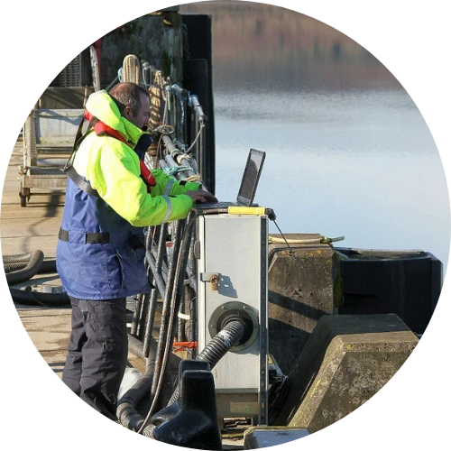
ADCP surveys can be undertaken either as part of an ongoing data gathering programme or as standalone bespoke projects. Equipment can be mounted in various configurations depending on project requirements:
Long-period seabed-mounted observations: Where it is necessary to gain a full understanding of current patterns in an area, long-period observations are carried out over at least a full tidal cycle through both neap and spring tides, or for a full lunar period of thirty days.
Short-period vessel-mounted surveys: Where there is a requirement to understand the current at a geographic point or over a wider area, but where a highly detailed long-term data set is not critical, relevant data can be obtained through vessel-mounted observations over a period of hours rather than days.
Single-point observations with electromagnetic sensors: Using electromagnetic sensors, it is possible to deploy equipment at a single depth for a specific period of time. This method provides high-quality current data at a single point within the water column.
ADCP data enables designers, engineers, and environmental bodies to accurately estimate water levels, tidal heights, the likely impact of any structure being placed in the area, and potential flood extents for coastal regions, rivers, and watercourses. The processed datasets undergo comprehensive error analysis with outlier identification and signal-to-noise ratio assessment, ensuring accuracy for integration into client-specific modelling environments.
FAQs on ADCP Monitoring
What does ADCP stand for?
ADCP stands for Acoustic Doppler Current Profiler, a hydroacoustic instrument similar to sonar that measures water current velocities throughout the water column using the Doppler effect of sound waves reflected from particles in the water.
How do you use an ADCP?
ADCPs can be mounted on the seabed in bespoke frames, attached to vessels for transect measurements, or deployed at fixed depths. The instrument transmits acoustic pings into the water column and analyses the frequency shift of returning signals to determine current velocities at various depths.
How do you process ADCP data?
ADCP data processing involves transferring raw data from the instrument to specialised software that converts acoustic signals from beam coordinates to earth coordinates (north–south, east–west, up–down). Quality control procedures identify and remove erroneous data before final analysis in industry-standard hydraulic modelling software.
What does an ADCP measure?
An ADCP measures water current speed and direction throughout the entire water column, creating vertical profiles at pre-determined depth intervals. The instrument can also record water temperature, heading, pitch, and roll, providing comprehensive data for analysing flow patterns and characteristics.
How do you read ADCP data?
ADCP data is typically visualised as velocity profiles showing current speed and direction at different depths. Data can be displayed as vector plots with arrows indicating flow direction and magnitude, or as time-series graphs showing changes in current patterns throughout measurement periods such as tidal cycles.
What is ADCP in hydrology?
In hydrology, ADCPs are essential instruments for measuring streamflow in rivers, monitoring tidal patterns in estuaries, and studying water movement in lakes and reservoirs. The technology allows hydrologists to obtain accurate discharge measurements across various waterways and understand complex flow dynamics for environmental and engineering applications.
Ready to discuss your ADCP & Current Monitoring Survey requirements?
Get in touch with SOCOTEC’s specialists today.

Discover our latest News & Media

Fire Resistance: Everything you wanted to know but were afraid to ask

Nature Positive Real Estate: Creating Value through Biodiversity

UKTC opens multi-million-pound state-of-the-art second firehall

Infinito Delicias. Building low-carbon spaces for communities to thrive

Mass Data Capture in Modern Surveying