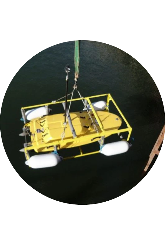
Geophysical Survey - Sub-Bottom Profiling
Sub-bottom profiling is a specialised acoustic technology used by marine geologists and engineers to detect changes in the acoustic impedance of subsurface geology.
These changes in density indicate transitions between different stratigraphic sequences beneath the seabed. This advanced geophysical survey technique serves a range of industries including offshore energy, telecommunications, and marine construction, enabling precise mapping of geological features critical for subsurface infrastructure planning.

Sub-Bottom Profiling
What is Sub-Bottom Profiling?
Sub-bottom profiling is a specialised geophysical survey technique that produces detailed images of the sub-bottom sediment and rock layers beneath the seafloor. The method emits low-frequency acoustic pulses toward the seabed, which penetrate below the surface and reflect back when encountering changes in sediment types or geological structures. These high-resolution images reveal stratified layers, buried channels, and other subsurface features not visible through conventional seafloor mapping.
Different sub-bottom profiling systems are designed for specific survey needs, with some optimised for shallow, high-detail imaging and others for deeper penetration. When combined with other geophysical survey tools like multibeam sonar or magnetometers, sub-bottom profilers provide comprehensive subsurface data essential for marine construction, environmental assessment, and archaeological investigations. The technique effectively maps various sediment types including sand, clay, and gravel deposits, while detecting buried objects and geological anomalies.
How Does a Sub-Bottom Profiler Work?
Step 1 – Emitting Sound Pulses
The system generates low-frequency acoustic signals via a transducer directed vertically at the seabed. Different profiler types (Chirp, Pinger, Boomer & Parametric) produce sound pulses at varying frequencies—typically between 2kHz and 20kHz—with each frequency range offering different penetration capabilities and resolution characteristics.
Step 2 – Penetrating the Water Column & Seabed
Sound pulses travel through the water column before striking the seafloor. Upon impact, a portion of the acoustic energy reflects back toward the surface, while the remainder penetrates the upper layers of substrate. The penetration depth varies based on sediment density, with finer materials allowing deeper signal propagation.
Step 3 – Recording & Converting Data
The returning sound pulses are detected by either the same transducer (Chirp/Pinger/Innomar) or a towed hydrophone (Boomer). These acoustic signals are digitised and processed to translate time differences and signal strength variations into visual representations of subsurface geological interfaces, revealing stratigraphic sequences beneath the seabed.
Sub-Bottom Profiling
Sub-Bottom Profiler Data Acquisition & Processing
Sub bottom profiler data acquisition involves the systematic collection of acoustic signals using shipboard computers. The raw data undergoes comprehensive processing through specialised filtering algorithms that remove noise and enhance signal clarity. This data processing allows for precise identification of stratigraphic horizons and subsurface anomalies through advanced interpretation techniques.
The workflow includes bottom tracking, amplitude analysis, and sediment classification. All sub-bottom profiler data is compatible with industry-standard SEG-Y format, enabling seamless integration with other geophysical datasets and third-party interpretation software for comprehensive site characterisation and geological modeling.
Sub-Bottom Profiling
Applications Across Industries
Sub-bottom profiling technology serves a range of industries through specialised geophysical survey applications. The versatility of these systems provides critical subsurface data for infrastructure development and research across diverse sectors.
- Pipeline detection using sub bottom profiler systems enables identification of both exposed and buried underwater pipelines, supporting offshore oil and gas infrastructure maintenance
- Offshore wind farm development relies on sub-bottom profiling to assess seabed conditions for cable routing and to identify potential obstacles like boulders that could damage equipment
- Marine archaeology applications include detection of shipwrecks and cultural artifacts buried beneath the seafloor, supporting preservation of underwater heritage sites
Limitations & Best Practices
While sub-bottom profiling is a powerful geophysical survey tool, certain conditions can affect data quality and feature detection. Optimum results are often obtained by utilising a combination of techniques, and we routinely undertake trial surveys to assess which sensors will provide the required results, ensuring clients receive an optimum dataset.
Key considerations include:
- Environmental noise from vessel traffic, weather conditions, and biological sources can interfere with acoustic signals
- Penetration limits in coarse materials such as gravel or consolidated rock may reduce the depth of investigation
- Data interpretation requires experienced analysts to distinguish between geological features, buried objects, and acoustic artifacts
A desktop geological report can be commissioned prior to the survey, incorporating supplementary seismic data, existing maps, and data from offshore and onshore borehole databases. This approach better informs all parties of likely conditions to be encountered within the survey area and helps set realistic expectations for feature detection.
FAQ about Sub-Bottom Profilers
Is a sub-bottom profiler considered seismic equipment?
Yes, sub-bottom profilers are classified as seismic equipment. They utilise reflection seismology principles to create 2D images of subsurface geology by emitting controlled acoustic energy that penetrates the seabed, revealing stratigraphic structures beneath the seafloor.
What is the difference between side scan sonar and a sub-bottom profiler?
Side scan sonar detects micro-topography and surface features of the seafloor by emitting sound waves at oblique angles. In contrast, sub-bottom profilers emit vertical sound pulses that penetrate beneath the seafloor to reveal stratigraphic structures and buried features within sediment layers.
What is sub-bottom profiling in simple terms?
Sub-bottom profiling is a technique that uses sound waves directed vertically at the seafloor to create images of what lies beneath. The system emits low-frequency acoustic pulses that penetrate sediment layers, revealing density changes and geological structures hidden below the seabed surface.
Discover latest News & Media

Fire Resistance: Everything you wanted to know but were afraid to ask

Nature Positive Real Estate: Creating Value through Biodiversity

UKTC opens multi-million-pound state-of-the-art second firehall

Infinito Delicias. Building low-carbon spaces for communities to thrive

Mass Data Capture in Modern Surveying