Magnetometer Surveys
A magnetometer survey is a specialised geophysical survey technique that measures variations in the Earth's magnetic field to detect and map anthropogenic and geological features across ground, marine, and airborne environments.
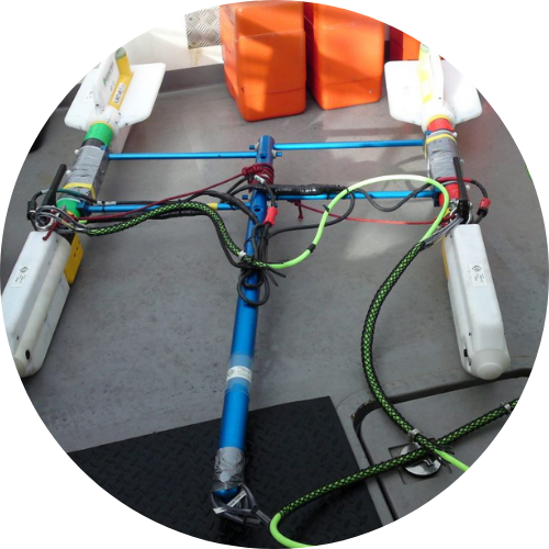
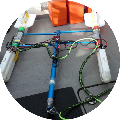
The magnetometer is typically towed behind a vessel or mounted to a UAV to avoid interference, identifying anomalies caused by metallic objects or magnetic minerals.
What is a magnetometer survey?
A magnetometer survey is a geophysical technique that measures variations in the Earth's magnetic field to detect and map subsurface features. The survey uses specialised sensors to record subtle changes in magnetic field strength caused by contrasting levels of magnetic susceptibility between buried features and the surrounding substrate. These variations reveal anthropogenic structures, geological formations, or ferrous objects that would otherwise remain hidden. The magnetometer is typically towed behind a vessel or mounted to a UAV to avoid interference, identifying anomalies caused by metallic objects or magnetic minerals that cannot be detected through visual inspection or conventional methods.
This technique serves construction developers requiring UXO clearance, archaeologists mapping historical sites, infrastructure managers locating buried pipelines, and mineral exploration companies identifying economically valuable deposits. It delivers safe site development through UXO detection, precise infrastructure location without excavation, cost-effective archaeological prospection, and efficient mineral resource identification across large areas. Companies typically require magnetometer surveys before commencing construction or development activities, during infrastructure maintenance planning, when conducting archaeological assessments, or when exploring potential mineral resources in previously inaccessible terrain.

How it works
Discovery
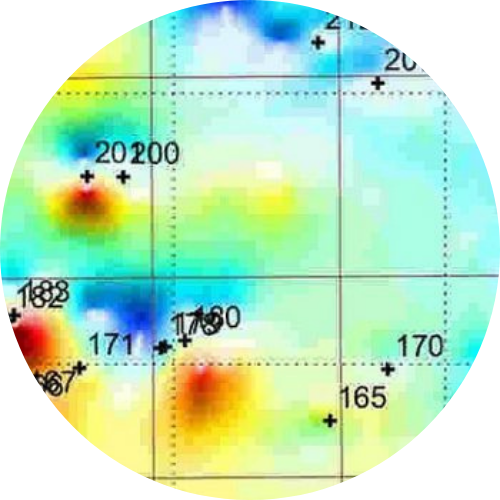
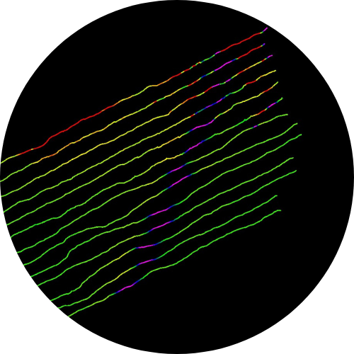
The process involves systematically collecting magnetic field data along predetermined grid lines with precise GNSS positioning. Sensors measure magnetic field variations by detecting changes in atomic spin states, creating contour maps that display the magnetism of the surveyed area.
Planning
Survey methodology is established based on target objectives—ground magnetometer surveys use systematic grid layouts (20m or 30m grids with 0.25m intervals); marine surveys employ towed sensors at 3-4 knots with 4Hz sampling; UAV surveys utilize lightweight fluxgate magnetometers for large or inaccessible areas.
Execution
Magnetic surveys detect two fundamental properties: magnetic susceptibility (a material's ability to become magnetised) and remanent magnetisation (permanent magnetism remaining after the external field is removed). Modern systems employ GNSS with centimetre accuracy, time-stamping each reading to 10 milliseconds precision.
Validation
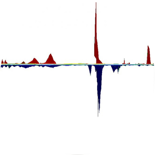
Post-processing software removes noise, applies filters, and generates visual representations of magnetic anomalies. Target identification algorithms automatically detect anomalies based on magnetic contrast thresholds, calculating position coordinates, burial depth, size estimation, and apparent mass calculations.

On-going Optimisation
Data is processed in real-time to monitor quality and make adjustments to survey parameters as required. Anomalies appear as steep gradients or rapid changes in magnetic readings, with features as small as a screwdriver identifiable when conditions permit.
Successful Outcomes
Detection Precision
Four readings per metre ensuring comprehensive site coverage with sub-nanotesla sensitivity
Depth Capability
Intrusive magnetometer survey techniques achieving detection to 25 metres—significantly exceeding conventional non-intrusive methods
Coverage Efficiency
UAV-based systems revolutionising large-area mapping with line spacing from 50cm (archaeological) to 4m (UXO detection projects)
Intrusive magnetometer survey capabilities
Why Choose SOCOTEC for Your Geophysical Survey
Intrusive magnetometer survey capabilities: Our specialists utilise Cone Penetration Testing (CPT) rigs fitted with advanced magnetometer probes capable of surveying to depths of up to 25 metres. This technology allows for precise identification of buried ferrous objects, from UXO to metallic structures, with detection capabilities within a 2-metre radius depending on soil conditions.
Compliance and certifications: Our services adhere to The Survey Association Level 4 and BSI PAS128 specifications, ensuring compliance with industry standards.
Proven geological expertise: We've successfully conducted complex investigations across varying geological conditions—from peat and tidal flat deposits to glacial till, providing clients with actionable subsurface data.
Integrated survey approach: We deliver comprehensive solutions by seamlessly integrating magnetometer surveys with complementary techniques including multibeam bathymetry and side-scan sonar systems. Our on-site monitoring ensures immediate anomaly identification, facilitating rapid risk mitigation decisions with minimal site disruption.
Learn More about Magnetometer Surveys
What is the purpose of a magnetometer?
A magnetometer is used to detect variations in the Earth's magnetic field and identify anomalies caused by objects or geological features. The primary purpose of magnetometer surveys is to locate and map ferrous objects, archaeological remains, UXO (unexploded ordnance), and geological structures. These surveys are particularly valuable for detecting everything from small ferrous objects like screwdrivers to larger structures such as pipelines, anchors, shipwreck debris, and buried infrastructure, provided the sensor is positioned within practical detection range of the target.
What kind of data can be collected from a magnetometer?
Magnetometer surveys collect systematic measurements of magnetic field variations at closely spaced intervals across the survey area. The data reveals magnetic anomalies that indicate the presence, size, depth, and characteristics of buried objects or geological features. Modern magnetometer systems can automatically log readings at high densities—typically four readings per meter—allowing for rapid collection of large datasets. Post-processing converts this magnetic data into modelled grids, providing target locations, depths, size estimates, and apparent weight calculations that can be exported in industry-standard formats.
What are the typical survey speeds and resolutions?
Survey speed directly impacts data quality and resolution. Typical sampling rates include: Ultra-high resolution (archaeological features) at 0.25-0.5m line spacing at 1-2m/s; High resolution (small UXO) at 1-2m line spacing at 2-3m/s; Standard resolution (pipelines) at 3-5m line spacing at 3-4m/s; and Reconnaissance (geological features) at 8-10m line spacing at 4-5m/s.
What are the limitations of magnetometer surveys?
Limitations primarily relate to interference from non-target sources. Highly magnetic geological materials, cultural noise from nearby infrastructure (fences, buildings, underground utilities), and ferromagnetic debris can obscure features of interest. Detection depth is constrained by sensor proximity to targets, with effectiveness diminishing as distance increases. Environmental factors such as geomagnetic micropulsations and temporal variations in the Earth's magnetic field may require correction during post-processing.
Ready to discuss your magnetometer survey requirements?
Get in touch with SOCOTEC’s specialists today.

Discover our latest News & Media

Fire Resistance: Everything you wanted to know but were afraid to ask

Nature Positive Real Estate: Creating Value through Biodiversity

UKTC opens multi-million-pound state-of-the-art second firehall

Infinito Delicias. Building low-carbon spaces for communities to thrive

Mass Data Capture in Modern Surveying