Contamination Assessment of Former Midlands Sewage Treatment Works Using TEM Survey Techniques
Challenge
A former landfill site in the Midlands was required to undergo testing, as historical operations posed potential groundwater contamination risks.
The site's proximity to residential areas and water courses demanded accurate contamination mapping for regulatory compliance, but previous investigation data was limited and inconclusive.
As a result, SOCOTEC UK & Ireland was contacted to help identify relict sludge tanks, trickle beds, and accessory infrastructure before planned development on the site.

Project Description and Overview
Project Description and Overview
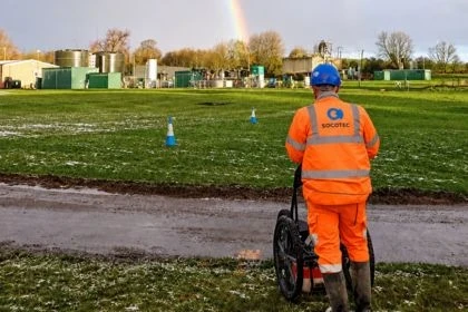
In October 2023, the survey commenced on the 4,000m² site, with investigations extending as deep as 6 metres below the surface.
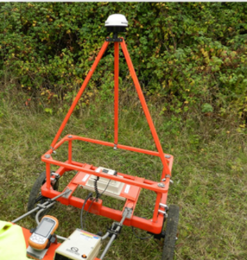
Due to the depths being surveyed, a transient electromagnetic survey was anticipated to be the best method to accurately map the buried infrastructure, when compared to the surrounding soil/made ground. Time Domain Electromagnetics (TDEM), also known as Transient Electromagnetics (TEM), is perfectly suited to locating targets of this nature.
An EM61-MK2 TEM system was used to survey the site, capable of analysing subsurface variations in induced voltage, providing bulk conductivity readings at varied depths.
In October 2023, the survey commenced on the 4,000m² site, with investigations extending as deep as 6 metres below the surface.
Due to the depths being surveyed, a transient electromagnetic survey was anticipated to be the best method to accurately map the buried infrastructure, when compared to the surrounding soil/made ground. Time Domain Electromagnetics (TDEM), also known as Transient Electromagnetics (TEM), is perfectly suited to locating targets of this nature.
An EM61-MK2 TEM system was used to survey the site, capable of analysing subsurface variations in induced voltage, providing bulk conductivity readings at varied depths.
Solution
Solution
SOCOTEC employed Time-Domain Electromagnetic (TEM/TDEM) survey technology, featuring:
- Data was collected at 1m intervals across the site, with the full TEM survey taking only 1 day
- 1D conductivity-depth modelling with 2D section generation
- Integration with existing borehole data for validation
A Ground Penetrating Radar (GPR) survey was also undertaken over the survey area, taking two days to fully map. The GPR survey was unable to resolve the targets in enough detail to produce a map of the relict infrastructure.
Conclusion
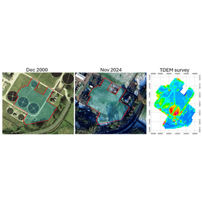
The relict sludge tanks and trickle beds were clearly identified within the TDEM/TEM data. When viewed alongside the historic imagery provided by Google Earth, a greater confidence in the data was achieved.
Want to find out more about...
Discover our latest News and Media

Fire Resistance: Everything you wanted to know but were afraid to ask

Nature Positive Real Estate: Creating Value through Biodiversity
UKTC opens multi-million-pound state-of-the-art second firehall

Infinito Delicias. Building low-carbon spaces for communities to thrive

Mass Data Capture in Modern Surveying

LEED in Practice: Sustainable Luxury in the Miami Design District

Passive Design as a Driver of Integrated Building Performance