4K Video Surveys- Streamline Your Road Network Management
Managing road networks is a complex task that demands accurate data for informed decisions on maintenance and investment. That's where we come in. We understand the challenges you face in balancing efficiency and cost-effectiveness across extensive networks.
Our 4K Video Surveys offer a practical solution. We use cutting-edge technology, providing you with clear and detailed information about your road infrastructure. This enables you to prioritise repairs effectively, optimise your budget allocation and ensure the long-term safety and durability of your assets.
Industries we support
Our 4K Video and Roadshow Software services support a wide range of clients, including:


By leveraging our expertise and state-of-the-art technology, we help our clients:
- Enhance decision-making with comprehensive, high-quality data
- Implement cost-effective road maintenance planning
- Improve road safety through early defect detection
- Ensure compliance with the latest industry standards (e.g. PAS2161:2024)
- Streamline asset and defect management processes
- Conduct efficient carriageway, footway, and cycleway condition assessments
Our services:
Roadshow Software
Overview
Roadshow is our License-Free proprietary software for presenting Video and GPR data to our clients. It is currently available in two formats depending on requirements:
Offline
The offline version of Roadshow is a standalone piece of software that can be used locally on your computer. The offline Roadshow Suite has a whole range of tools and customisation options for querying your data.
This is usually delivered to the client via a download link from our secure servers or removeable media.
Online
Our Roadshow Software is now fully available online. This makes all of your data available at incredible convenience though our secure web portal. All of your Video and GPR data in one place so repeat surveys can easily be toggled between to monitor and review changes to your assets and defects. Our high-quality mapping and GPS positional accuracy can display all asset and defect types geospatially. These can then be monitored, edited or deleted by the user. You are also able to create new items, as to either establish or fill in the gaps of your existing inventory.
![]()
4K Video Surveys
Our 4K Video surveys are collected at true traffic speed, meaning there is no need for expensive and time-consuming traffic management. With a totally modular system we really can tailor the results you will receive to match the objectives of the survey. For example, if you are assessing Gullys, we can point a camera directly at them. Each view is a true 3840 x 2160 pixels giving an 8.3MP image.
The data is collected in 4K resolution with high accuracy GPS and Wheel Encoder inputs. This allows us to present your data with extremely high accuracy. See above for more information on how your data can be presented in Roadshow. See below an example of 4K (left) vs regular HD (right).
Asset and Defect Management
On-Carriageway
You can use our Roadshow software and mapping to geospatially position a wide variety of on-carriageway assets and defects. These include:
- Longitudinal and Transverse Lines
- Road Markings
- Road Studs
- Hatchings, Chevrons, Tiger Tails and Box Junctions
- Defects on the running lanes
Off-Carriageway
Similar to on-carriageway, you can use the Roadshow software and mapping to geospatially map a wide variety of off carriageway assets and defects also. With our additional camera views clearly pointing off-carriageway you can assess all that is required in 4K resolution. Some off-carriageway assets/defects include:
- Traffic Signs
- Vehicle Restraint Systems (VRS)
- Lighting Columns
- Traffic Lights
- Comms Cabinets
- Vegetation Management
- …
The list is endless. Please enquire for more information on how we can meet your survey needs.
Automatic Traffic Sign Detection
Our Traffic Sign Recognition System has two stages – 1. Detection and 2. Recognition. Our system utilised 4K video data collection alongside a specifically trained AI model to accurately locate and categorise the traffic signs on your network. We are able to identify things such as:
- Diagram Number
- Colours
- Sign Plate Shape and Size
- Sign Condition
All of these reference to the UKPMS Traffic Signs Manual.
Carriageway Condition
AI Defect Detection
We have a fully developed system using our 4K Video to locate and analyse certain carriageway defects. This is achieved by using our high-quality video and computer learning software. We have fed 1000's of manually collected defects into the software since its inception to allow it to automatically, and more importantly accurately identify defects by itself.
Vertical Panorama
We have developed a method for taking our standard 4K Vertical View and intelligently stitching it together using GPS to display the carriageway in a real image strip-plan format. This then allows the user or AI to locate and annotate carriageway defects normally associated with CS229 type Visual Condition Surveys (VCS).
Visual condition Survey (VCS)
Using our 4K video we can complete traditional VCS surveys that are fully compliant with “CS229 – Data for pavement assessment”. The output for these surveys is a PDF report with photographs, defects in csv format including OSGR’s and Strip Plans.
PAS2161:2024
The PAS is designed to standardise the methodology for the data capture, processing and reporting of RCM data. This ensures uniformity across different networks. By defining clear condition categories for carriageway networks, the PAS aims to promote a consistent understanding and assessment of road health. This will then feed directing into the DfT Reporting requirements.
We have been producing routine Visual Condition Surveys for the UK transport sector since 1995. Initially using traditional on-site methods before switching to HD Video and now using multi-View 4K Ultra-High Resolution. Using a combination of highly experienced engineers and Artificial Intelligence, assessing your network has never been easier.
Get your free copy of PAS2161:2024 here: PAS 2161:2024 | 30 Sep 2024 | BSI Knowledge
CVI / DVI Surveys
Coarse Visual Inspection (CVI) are used to record the presence of defective areas of carriageway, footway and kerbing. These are conducted from a vehicle and enable the recording of such defects as cracking, crazing and rutting. CVI surveys are performed to national standards.
Detailed Visual Inspection (DVI) surveys enable the collection of much more detail relevant to defects on roads and pavements. Such defects as cracking, subsidence, chip loss and the like are all recorded, together with their associated dimensions.
The primary use of such surveys is to assess the condition of the busier pavements on your network.
Both types of survey can assist you with the appointment of budgets for future maintenance works.
Our unique, 4K imagery gives an unparallel visual track record of the road surface condition for both CVI and DVI applications from the safety and reliability of a desktop study.
High Friction Surfacing (HFS)
Using our 4K Vertical imagery we have developed an AI system which analyses each frame to provide an accurate High Friction Surfacing (HFS) inventory and subsequent analysis. The model analyses the full carriageway width and determines the quantity of material that is lost and thus deteriorated. This is then reported in either HAPMS (P-AMS) Chainage or geospatially.
Footway Condition
Where footways cannot be seen from the main carriageway, we use multiple 4K cameras mounted on a tricycle to ensure full coverage of your footway network. The resultant videos can be viewed in our Roadshow software suites which provide the user a 360-degree view from the current position shown on a map. From this we are able to locate and record multiple defect and asset types.
Cycleway Condition
In the case of the Safer Cycling Video Survey (SCVS) the cameras are mounted on a tricycle around head height. Both on-carriageway and off-carriageway cycleways can be surveyed. The resultant videos can be viewed in our Roadshow software suites which provide the user a 360-degree view from the current position shown on a map. The uses are plentiful and in the case of the SCVS it gives the “cyclist” view and danger spots for cyclists can be identified.
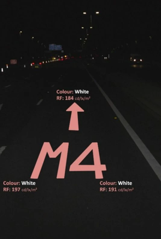
Retroreflectivity Surveys - Traffic Signs
By using a 4K Digital Video System calibrated to the human eye instead of using retroreflectivity meters, actual sign performance can be measured in terms of the true sign interaction with the driver where other factors, such as sign orientation and obstructions, can be taken into consideration.
As always with video systems, they allow a greater degree of quality assurance rather than relying on discrete measures, which in this case are taken from retroreflectivity meters.
The sign images are stored and archived. With more and more traffic on the UK’s roads and Hardshoulder running it is no longer possible to carry out the traditional methods due to safety concerns.
Not only is Traffic Speed Retroreflectivity cost effective it is inherently safe and produces consistent results to allow comparisons year on year.
Retroreflectivity - Line Markings and Symbols
Using 4K imagery captured at night combined with specifically calibrated lighting we are able to obtain the retroreflectivity of line markings. The value of retroreflectivity determines the visibility of the line markings at night. Our research programme has produced algorithms to convert grey-scale intensity to Retroreflectivity Luminance (mcd.m-2.lx-1)
The system operates at traffic speed and the lines are illuminated by a high intensity LED source. The receiving CCDs are calibrated to reproduce comparable grey-scale outputs. The system collects left and right edge line marking retroreflectivity simultaneously from the digital video. Analysis is automated and outputs are a measurement of retroreflectivity averaged over 2 meters in Geo-Referenced form.
Line These results can be statistically analysed along with street lighting information to produce green, amber and red traffic light style output to highlight the areas requiring improvement. Outputs are in CSV, Shapefiles or as per the client’s specific requirements.
Retroreflectivity Surveys - Road Studs
Using the same methodology as we use to detect line marking retroreflectivity we are also able to automatically locate road studs and measure their Retroreflectivity Luminance (mcd.m-2.lx-1).
The system operates at traffic speed and the studs are illuminated by a specifically calibrated LED source. The receiving CCD's are then calibrated to reproduce comparable grey-scale outputs. The grey-scale values are converted to retroreflectivity luminance using Impulse Geophysics proprietary algorithms. Along with the automatic detection of the Roadstuds colour we can then determine whether the stud is working and reflecting as intended.
Daytime Marking Luminance
By using our 4K Video and automatic detection techniques, we can analyse the contrast and condition of your line markings and symbols to determine their "real" daytime visibility to the road user. This ensures that whatever construction your carriageway is, your line markings are providing a safe and clear picture of the road ahead.
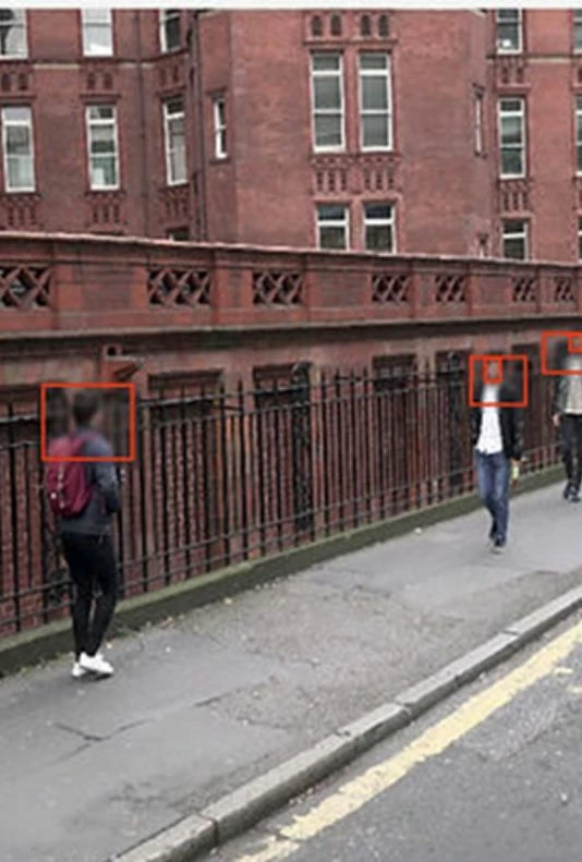
Video Redaction
We understand that your data is sensitive and could be harmful should it fall into the wrong hands. This is why we offer full redaction of your video data. This involved the blurring of all Personally Identifiable Information (PII) in the form of Registration Plates and Faces. We can also redact any information if required. For example, Road Traffic Incidents. *This service must be requested at the time of purchase as the standard video delivery is un-redacted.
Our 4K Video surveys, collected at true traffic speed, eliminate the need for expensive and time-consuming traffic management. With a modular system, we tailor results to match your specific survey objectives, whether you're assessing gullies, road markings, or overall road conditions.

Roadshow Software and Video Surveys
Benefits
- Enhanced decision-making with comprehensive, high-quality data
- Cost-effective road maintenance planning
- Improved road safety through early defect detection
- Compliance with latest industry standards (PAS2161:2024)
- Versatile applications including CVI/DVI Surveys, High Friction Surfacing (HFS) assessment, and Footway/Cycleway Condition analysis.
Roadshow Software and Video Surveys
Why Choose Us?
- Industry-leading technology combining AI and human expertise
- Comprehensive suite of services covering all aspects of road asset management
- Compliance with latest standards and regulations
- Proven track record of successful implementations
- Dedicated team of road infrastructure experts.
- Industry-leading technology combining AI and human expertise
- Comprehensive suite of services covering all aspects of road asset management
- Compliance with latest standards and regulations
- Proven track record of successful implementations
- Dedicated team of road infrastructure experts.
Let's Talk Roadshow Software and 4K Video Surveys
Get in touch with our Roadshow Software and 4K Video Surveys experts to discuss solutions to enhance your air quality management.

You might also be interested in:
SOCOTEC UK & Ireland Celebrates Double Success at the Ground Engineering Awards
SOCOTEC UK & Ireland Strengthens Infrastructure Capabilities with Strategic Acquisition of LSTC Group
LDG Datum returns to Hillhead show for 2026 with SOCOTEC backing
SOCOTEC nominated for trio of ground engineering excellence awards
Discover the Future of Highway Surveys: Traffic Speed Video & GPR Insights