Geological & Utility Desktop Surveys
Early insight that helps you understand site constraints before work begins.
Desktop surveys bring together existing records and datasets to provide an informed view of subsurface constraints at the earliest stages of a project. They support safer planning, proportionate risk management and clearer decision-making before design is fixed or intrusive works begin.
SOCOTEC delivers desktop surveys through our specialist teams. Particularly focused on utility records and the other on geology and ground conditions, together, these services provide a structured starting point for understanding subsurface constraints, without unnecessary complexity.

Geological & Utility Desktop Surveys
Why Desktop Surveys Matter
Early project decisions are often made with limited information. Desktop surveys help reduce that uncertainty by identifying known constraints before they affect programme, cost or safety.
Desktop surveys matter because they help you to:
- identify subsurface risks at feasibility and pre-design stages
- avoid preventable clashes, redesign and delays
- plan proportionate follow-on surveys and investigations
- demonstrate a considered, auditable approach to risk management
- improve confidence in early design and site planning
They provide clarity when it is most valuable, before work on site begins.
Our approach to desktop surveys
Our teams source, review and quality-check relevant records and datasets, applying professional judgement to ensure outputs are clear, relevant and ready to use. We focus on presenting information in a way that supports action, not just compliance, with separate deliverables for utilities and geology, depending on what you need.
Desktop surveys can be commissioned individually or together, depending on project requirements.
Desktop Surveys Explained
Desktop Utility Surveys (PAS 128)
Desktop Utility Surveys focus on identifying known buried services using statutory undertaker records for a defined site area.
Delivered in accordance with PAS 128, this desk-based service collates utility records from all relevant providers and presents them in a composite CAD plan, supported by a full report pack.
Desktop utility surveys:
- identify recorded utility assets only
- do not confirm depth, condition or exact location
- provide essential background for intrusive PAS 128 surveys
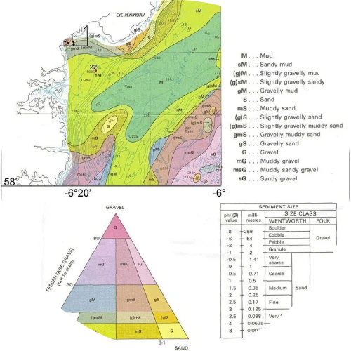
Desktop Geological Studies
Desktop Geological Studies are a cost-effective risk reduction tool, providing an early yet comprehensive understanding of the likely ground and operating environment before survey mobilisation or site works begin.
These studies compile and interpret existing geological, environmental and historical datasets to support feasibility assessment, route selection and design development. They are commonly used to focus survey effort, identify likely challenges early and ensure that equipment, methodologies and resources are proportionate to site conditions.
By highlighting potential constraints before mobilisation, desktop geological studies help reduce avoidable cost, improve efficiency and minimise the risk of unforeseen issues emerging later in a project.
Desktop geological studies:
- assess anticipated ground conditions and constraints
- access available geotechnical & borehole records
- identify potential geohazards and legacy issues
- inform ground investigation scope and design development
- are not PAS 128 surveys and do not identify utilities
Geological & Utility Desktop Surveys
What desktop surveys help you understand

Depending on the project, a desktop geological study may draw on a wide range of existing information, including:
- Bathymetric charts and seabed mapping
- Published geological records and seabed geomorphology
- Historical land use and legacy constraints
- Environmentally sensitive areas (including SSSIs)
- Known shipwrecks and existing offshore or nearshore infrastructure
- Potential natural and anthropogenic hazards
- Available metocean observations
- Client-owned data, such as previous reports or environmental studies
This information is reviewed and interpreted to identify preliminary operational areas, assess feasibility and inform survey planning prior to on-site deployment.
Typical applications
Desktop surveys are commonly used to support:
- feasibility and site appraisal
- pre-design and concept development
- early infrastructure and layout planning
- preparation for intrusive utility or ground investigations
- recommend most suitable geophysical survey methods
- enabling works and excavation planning

Discover our latest News & Media

Fire Resistance: Everything you wanted to know but were afraid to ask

Nature Positive Real Estate: Creating Value through Biodiversity

UKTC opens multi-million-pound state-of-the-art second firehall

Infinito Delicias. Building low-carbon spaces for communities to thrive

Mass Data Capture in Modern Surveying

LEED in Practice: Sustainable Luxury in the Miami Design District

Passive Design as a Driver of Integrated Building Performance