Need some advice?
Leave your details and we will get in touch.
I want to be contacted by an expert1 /

When a development site is located near or above underground infrastructure – such as rail tunnels or utilities - and the project requires piling, excavation or other sub-surface works, conducting a line and level correlation survey is the critical first step in understanding the geospatial relationship between the proposed construction works and the existing below ground asset. Without this knowledge, the owners of the underground asset will not grant permission for works to proceed.

Working closely with developers and project managers, SOCOTEC Monitoring has vast experience of conducting line and level correlation surveys to satisfy underground asset owners’ requirements, assisting developers with project approvals and ensuring that proposed works will not impact any existing underground structures.
Before any development located in the vicinity of a tunnel or other rail asset is approved, agreement in principle to carry out the works is required from the owners of the asset, for example Network Rail, Transport for London or London Underground. Having first accessed general map data and established that the proposed development is near to an underground tunnel, the contractor intending to carry out the works is required to seek this agreement in principle which, in the case of Network Rail, is known as the Basic Asset Protection Agreement or BAPA.
To be eligible to seek this agreement, a line and level correlation survey – also known as a surface to sub-surface correlation survey, or a surface to sub-surface relationship survey - is required to provide the contractor with information about the exact positioning of the running rails or tunnel structures in relation to the proposed development works. Linking the resulting data with an existing topographic or measured building survey on the same grid can predict the estimated impact to any rail infrastructure.
Equipped with the data and insight to demonstrate likely impact on adjacent rail structures, contractors can then approach the asset owners to seek the required permission for the project. Any required adjustments can be made to the design at this stage, which might involve changing piling locations or adapting the programme of works to abide by the asset owner’s specific requirements, taking into account minimum distance stipulations or maximum weight restrictions, for example.
A summary of the benefits of conducting a line and level correlation survey includes:
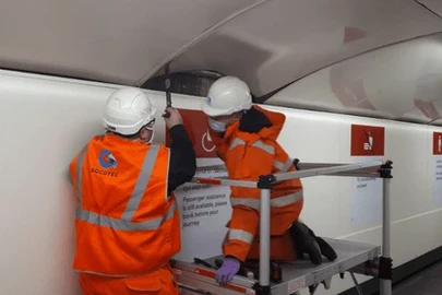
Conducting a line and level correlation survey requires a high level of knowledge of the fundamentals of land surveying and use of specialised equipment. At SOCOTEC Monitoring, total stations are used to conduct line and level correlation surveys, simultaneously measuring angles and distances. It is vital that measurements are gathered with a high degree of accuracy, and that the asset owner’s individual standards are adhered to.
If the relative position of the surface structure and the sub surface structure is not known accurately, or are shown incorrectly, there is a risk that excavation or piling works could be carried out too close to the tunnel, causing movement or even breakthrough into the tunnel itself.
The process for carrying out a line and level correlation survey is therefore precise, and involves establishing a closed loop control traverse from the surface site development to the sub surface structure below, for example a London Underground tunnel, via the two adjacent stations on that Underground Line in X, Y and Z directions. This creates a robust control network from which the accuracy can be determined.
Along the surveyed route, the asset owner will likely already have control established in the form of an existing topographic or measured building survey. The results of the line and level correlation survey will be linked to this control on the same grid to understand the relationship between them, which allows predictions to be made about the possible impact to any existing rail infrastructure.
For example, when working with London Underground, SOCOTEC Monitoring links to two separate drawings:
How long a line and level correlation survey takes depends on the distance between the two underground stations either side of the development. Normally, however, SOCOTEC Monitoring allows 1-2 night shifts to complete the sub surface phase of the traverse, and 1-2 day shifts for the surface phase.
For the majority of clients, the survey is exported as AutoCAD DWG files and MicroStation DGN files, but occasionally clients also require a 3D model of the survey.
The results of the line and level correlation survey determines what additional surveying and monitoring is required, so it is the crucial first step of a project. Once this has been completed and project approval has been granted, a condition survey to benchmark pre-existing conditions follows, along with track geometry surveys, clearance assessments and more.
With decades’ of experience working on rail infrastructure, the SOCOTEC Monitoring team can arrange everything on a client’s behalf, including access, risk assessments, TARA (Threat Assessment and Remediation Analysis), health and safety documentation, safe working procedures, and more, taking the stress out of the task required.
For more information about SOCOTEC Monitoring’s surveying capabilities, click here. Or, to speak to a member of our team about your requirements, please get in touch.
Want to find out more about SOCOTEC Monitoring's services?